Pueblo Shuar Arutam, Ecuador
General information about Shuar Arutam People
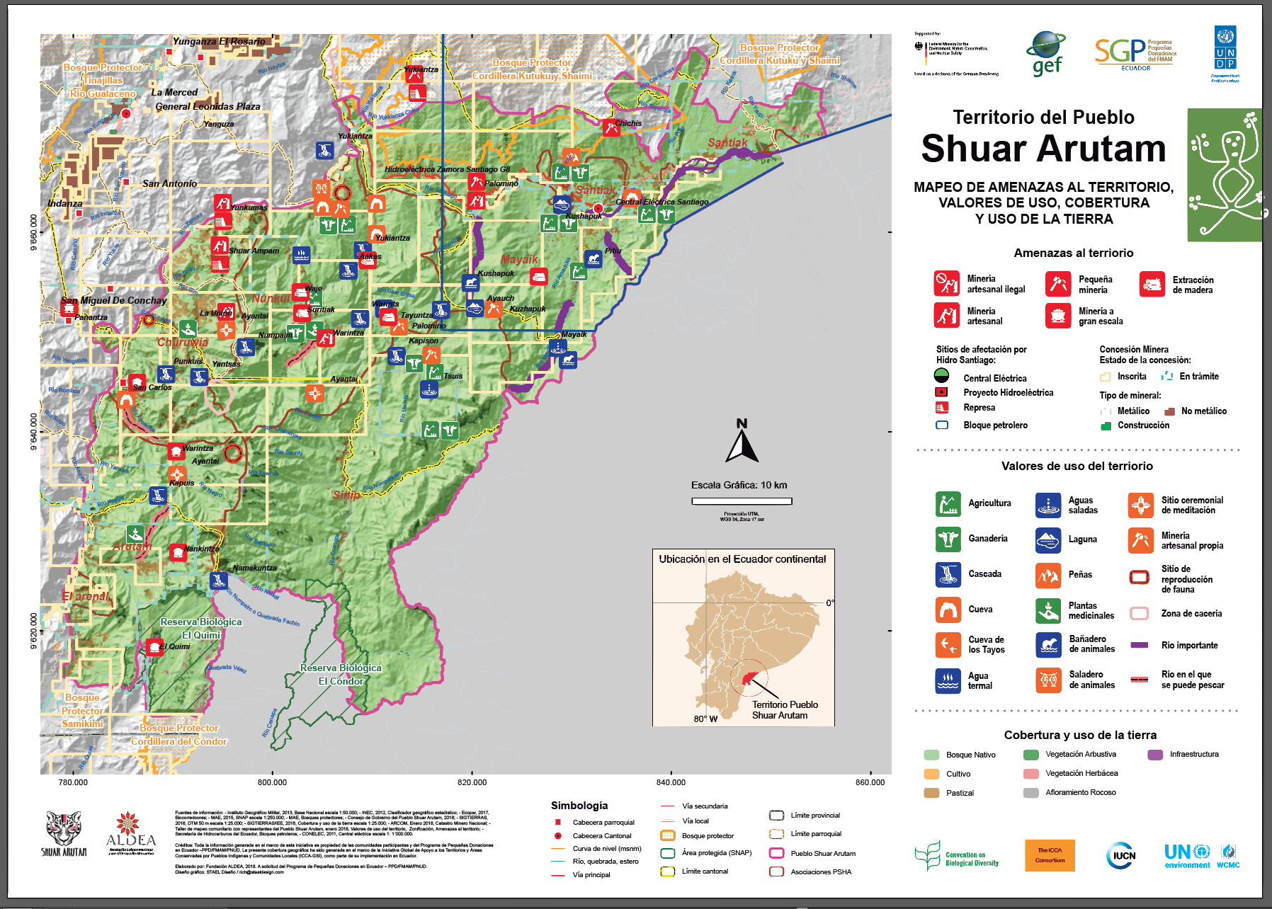
The territory of the PSHA is located in the southeast of the province Morona Santiago, in the Cordillera del Cóndor, between the rivers Santiago, Zamora and Kuankus, bordering the south with Peru.
The territory of the PSHA has approximately 233,169.73 hectares and is composed of 6 Shuar Associations that group 47 communities. Next, a list of communities by Association, made after the revision of the Atlas of the Shuar Arutam People (Kingman, 2010), and updated with the CGPSHA of September 2, 2017, during the second participatory workshop within the self-strengthening process
The story
The Cenepa War (1941-1995), between the governments of Ecuador and Peru, was decisive in the territory of the Shuar nationality that lives in both countries. Both the Ecuadorian and Peruvian army recruited Shuar people who played an important role as warriors.
On the other hand, by the Peace agreements, the Binational project for Peace and Conservation in the Cordillera del Cóndor was established, with the aim of promoting “sustainable development” and creating a protected area in Shuar territory, in addition to the newly created El Condor Binational Park. The Shuar did not agree to create a public protected area in their territory, but they did see fit to create a territorial constituency, as a defense strategy against mining and colonization.
In 2003 the organization was formalized, after the first General Assembly, and in 2006 the Development Council of the Nationalities and Peoples of Ecuador (CODENPE) legalized its organizational structure, the PSHA Governing Council (Kingman, 2010).
In recent years, the organization has been very pressured by the wealth of copper and gold found in the subsoil of its territory, which has raised the conflict in the area.
The territory
The territory of the PSHA is part of the Amazon rainforest ecosystem. It is nestled in the Cordillera del Cóndor, a sub-Andean mountain formation, consisting mainly of sandstone and limestone rocks. It is part of the Abiseo-Condor-Kutukú bio-corridor, connecting the tropical Andes hotspot and the large wild area of the Amazonian tropical forest.
PSHA protects areas of great biological importance as water sources and niches of great biodiversity, thus conserving the Amazon rainforest, habitat of numerous endemic species, and living environment of the Shuar culture, where its sacred spaces are also located .
Linking with the territory
As for its economic and productive activities, the PSHA is especially maintained in the self-sustaining agricultural activity. Subsistence agriculture is based on ajas, a traditional Shuar agricultural system integrated into the forest. There is also livestock, hunting, fishing and logging (CGPSHA, 2016).
In 2008, the PSHA entered the government program Sociobosque10, with which an agreement is currently being maintained to conserve 83,915 hectares of unexploited Amazon rainforest (map 3) representing 35.98% of its territory.
The Sociobosque program requires compliance with conservation to execute semiannual payments for forest conservation. Thus, monitoring of forests at the community level is necessary; PSHA has established control mechanisms for this with trained personnel, budget and planning.
Governance
The Governing Council of the PSHA is composed of an executive council, an advisory body and another of oversight and control and the presidents of the associations. They meet monthly to analyze the axes of management: territory, natural resources, agriculture, health, education and communication. Each axis has an executive and four or more technicians chosen in assemblies.
Regarding the conservation issue, the Natural Resources executive coordinates monitoring with local technicians to analyze that the management guidelines established within the PSHA and with Sociobosque are being met. The organic structure of the PSHA means that the responsibility for making decisions does not fall on a single person or leader but on the assembly spaces at their different levels.
Territory threats
For PSHA, mining and logging is the main external threat to its territory. Since the 60s, the extinct Ecuadorian Institute of Agrarian Reform and Colonization (IERAC) assigned titles to settlers and religious orders without taking into account that these were ancestral territories of Shuar communities. These qualifications make some people with titles sell to companies or other actors fragmenting the ancestral shuar territory.
The biodiversity, towns and culture of the Cordillera del Cóndor are currently threatened by several large-scale metal mining projects. In the year 1993, the first mining concessions that affect the Shuar territory organized today in the PSHA were delivered. The Cordillera del Cóndor is currently being affected especially.
Lessons learned and routes to follow
The initial vision that created PSHA is a long-term guiding axis. This vision is that of a Shuar territory with authority and execution of its own government, financed by the State and cooperating, as an administrative division of the State recognized under the constitutional figure of CTI, respected in its autonomy and self-determination, in the exercise of the Plurinational State.
This also includes self-determination on its integral territory, which means the active and decisive participation on the soil and subsoil resources, which are interdependent with each other and with the life of the Shuar that inhabit it.
PSHA works to improve the quality of life of families from the sustainable use of livelihoods, the use of cultural, scientific, technological and artistic potential of their communities. It is proposed to be a shuar government with autonomy, sustain the Shuar culture, design and execute programs and projects for the sustainable management of their livelihoods, implement policies for mitigation and adaptation to climate change (CGPSHA, 2016).
This case study was originally published by UNEP-WCMC in April 2020. The content was provided by the custodians of this ICCA. This case study was facilitated by the Small Grants Program in Ecuador (PPD/GEF/UNDP - GSI ICCA), in collaboration with the Latin American Association for Alternative Development (ALDEA). The ICCA has been self-declared and has been through a peer-review process to verify its status. More details on this process can be found here. The contents of this website do not necessarily reflect the views or policies of UN Environment Programme or WCMC.
The photographs in this case study are from the Small Grants Programme in Ecuador (SGP/GEF/UNDP- GSI ICCA), the collaboration agreement signed with ALDEA indicated that the production, audiovisual, photographic material or generation of documents within the framework of the GSI-ICCA/PPD project are from the PPD.